What Did Captain William Clark “Sea” on November 7, 1805?

On November 7, 1805, the Corps of Discovery was paddling around islands in heavy fog as it made its way toward the mouth of the Columbia River, stopping periodically to trade with the Indians they encountered on their downstream voyage. They were now entering Chinookan country. At a landmark known as Pillar Rock, Captain William Clark recorded some of the most famous words of the expedition’s collective accounts:
“Great joy in camp we are in View of the Ocian, this great Pacific Octean which we been So long anxious to See. and the roreing or noise made by the waves brakeing on the rockey Shores (as I Suppose) may be heard distinctly”
The Corps of Discovery was now in sight of the objective they had labored to reach for more than 4,000 miles and 18 months. Little wonder that Clark wrote, with such atypical fervor, “O! the joy.” But what did the good captain see? And was it the sea? For almost a century the prevailing historical wisdom has been that Clark was mistaken in his recorded observation, and that the Corps would not “see the sea” for many more days — during which period they would be savaged by powerful Pacific storms.
“The ocean could not possibly be seen from this point.” – Reuben Gold Thwaites
This scholarly challenge to Clark’s veracity dates back to a time when preparations were under way for the Lewis & Clark Centennial. Writers retraced the Corp of Discovery’s journey, aided by the first edition of Lewis and Clark’s complete journals (yes, it took that long to get the them published — but that’s another story). Based on second hand information, the editor, Reuben Gold Thwaites, included a footnote beneath the day of November 7, 1805 that read:
“The ocean could not possibly be seen from this point.”
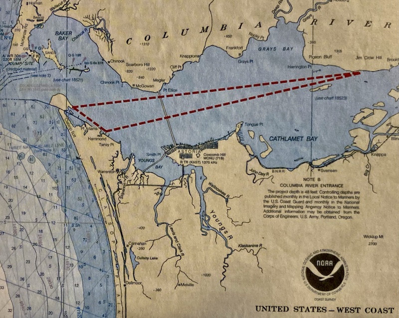
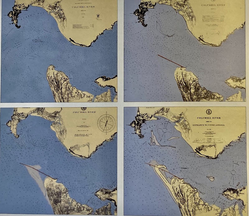
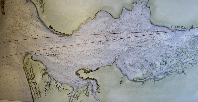
That little footnote made a compelling case for believing that William Clark had been swept up in a combination of misidentification and exuberance — one that can easily be affirmed by taking a simple line of sight from the point on the Washington side of the river where the Corps was camped and superimposing it over a map of the Columbia River’s mouth. You can’t see the sea. The conventional wisdom regarding what Clark actually saw, since it clearly wasn’t the Pacific, is that it was the Columbia River Estuary, between Altoona and Grays Bay.
“They did not make a mistake.” – Max Ziak
Max Ziak would beg to differ regarding the above explanation. In his meticulous and immersive account of the 30 days the Corps of Discovery spent at the mouth of the Columbia River between November 7 to December 7, 1805, entitled In Full View, the Astoria, Oregon-based historian and cinematographer boldly states, “I believe that Lewis and Clark did see the ocean, precisely as they claimed in their journals, on November 7, 1805. They did not make a mistake.”
I should here point out Ziak also agrees that there is no way you can see the Pacific Ocean from where Lewis & Clark were camped on November 7, 1805. He reconciles this obvious contradiction with a “crucial piece of information”: “The mouth of the Columbia River is not now in the same position as it was in 1805. The mouth of this great river has moved.”
As Ziak explains it, a half century following the Corps of Discovery’s journey, as settlers arrived in the Oregon Territory in the 1850s, the Columbia River became increasingly vital to shipping traffic. The treacherous mouth of Columbia that Lewis & Clark experienced in the period Ziak details in his book (it’s a brilliant read, by the way) proved to be a major obstacle to shipping, which placed a drag on the region’s development. Following years of studies, surveys, and debate, the government committed to the construction of an enormous breakwater.
The South Jetty
The breakwater was a marvel of brute force and early 20th century engineering. A railroad trestle more than four miles long was built out into the ocean. Upriver, rocks were blasted out of stony hills, loaded onto barges, and floated toward Point Adams. From here they were loaded onto train cars to be dumped into the sea.
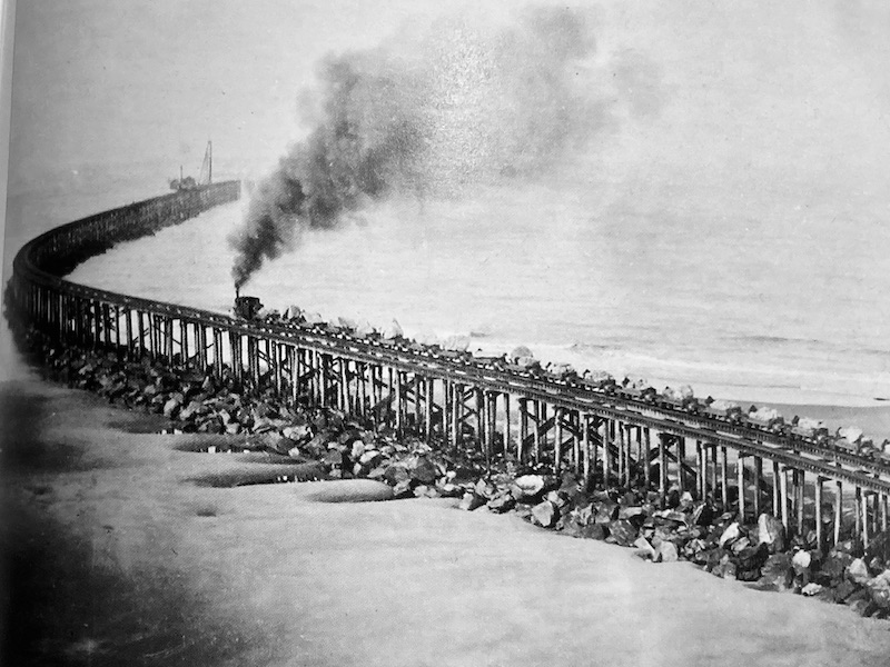
“Over the next decade, between 1885 and 1895,” Ziak writes, “millions of tons of rock were placed in the ocean. Eventually the rock settled and its level rose above the waves. The construction of this ‘South Jetty’ was the largest pubic works project in the history of the United States.”
“The mouth of this great river has moved.” – Max Ziak
The jetty had its desired impact: it changed the flow of the Columbia River, deepening the channel for ships and blocking the surge of ocean waves. As sand accumulated along the breakwater, Clatsop Spit was formed and vegetation took hold. Ziak reports that, “By 1900, a young forest of nearly 3,000 acres was growing where fifteen years earlier there had been only surf.”
This surf, I might add, was at the source of what Captain William Clark observed on November 7, 1805. It wasn’t Grays Bay, which, as Ziak points out, “…happens to be around a point and is impossible to see without a helicopter.” And as tp the suggestion that they might have mistaken an estuary for an ocean? Oh, please. That, Ziak maintains, “…makes even less sense.”
It’s hard to refute the testimony Max Ziak offers on behalf of William Clark’s powers of observation. This is the man, after all, whose calculation of his expedition’s journey from the mouth of the Missouri to the mouth of the Columbia was only off by about 40 miles. But he does offer some additional evidence to bolster his position.
The Last Word
The Corps of Discovery continued down to the coast after leaving their camp of November 7, and then returned to the same site 18 days later. At this point, Ziak logically argues, Lewis and Clark would have had no doubts as to what they were seeing when they looked west. You would think they would have corrected their journals upon discovering an error in their previous observations. Six days after that, while weather forced the expedition’s halt along the shoreline, Clark wrote about the sound of the crashing surf, noting it was the sound they had been hearing, “…ever Since our arrival in its borders which is now 24 Days Since we arrived in Sight of the Great Western Ocian.”
Clark’s reference to “24 days” was not an arbitrary number, Ziak points out. Do the math. The journal entry was December 1. Count back 24 days and you arrive at November 7 — the day Captain William Clark saw the sea.
How do you like us now, Reuben Gold Thwaites?