Geography is Destiny: A Brief History of Mount Vernon, WA
The city of Mount Vernon makes a strong case for something my Uncle Dave (Dr. David W. Lantis), a professor of geography at Chico State University, impressed upon me at an early age: geography is destiny. This has certainly has been true for the county seat of the Skagit Valley — a place my wife and I have had the good fortune to call home for more than a dozen years now.
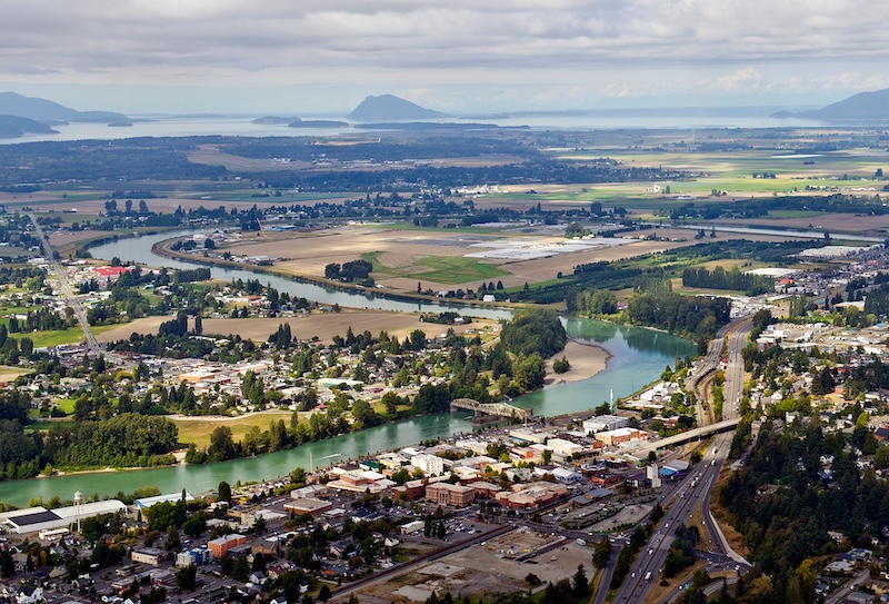
Situated beside the Skagit River in one of the most fertile valleys of the Pacific Northwest, it’s no surprise that Mount Vernon developed from a small river settlement into the commercial and governmental center of the Magic Skagit. Its history, going back to “time immemorial,” encompasses Indigenous peoples, pioneer settlement, logging and agriculture, steamboats and railroads, destructive fires and floods, highway construction, and the continuing effort to preserve both farmland and a historic downtown identity. Through all of these changes, the Skagit River (the largest river flowing into Puget Sound) has remained Mount Vernon’s most defining feature.
Long before an American town existed here, the Skagit River basin was home to Coast Salish peoples whose communities depended upon the river and surrounding forests for salmon, game, plants, transportation, and trade. The Upper Skagit people comprised a number of distinct bands and villages extending along the river toward the Cascade Mountains. Among them were the Nookachamps, whose territory included the vicinity of present-day Mount Vernon. Representatives of Skagit peoples were among the Native signatories of the 1855 Treaty of Point Elliott, an agreement that dramatically altered Native land ownership while reserving important treaty rights, including fishing, thanks to the diligence of generations of Coast Salish peoples who have held the American government accountable for its end of the deal.
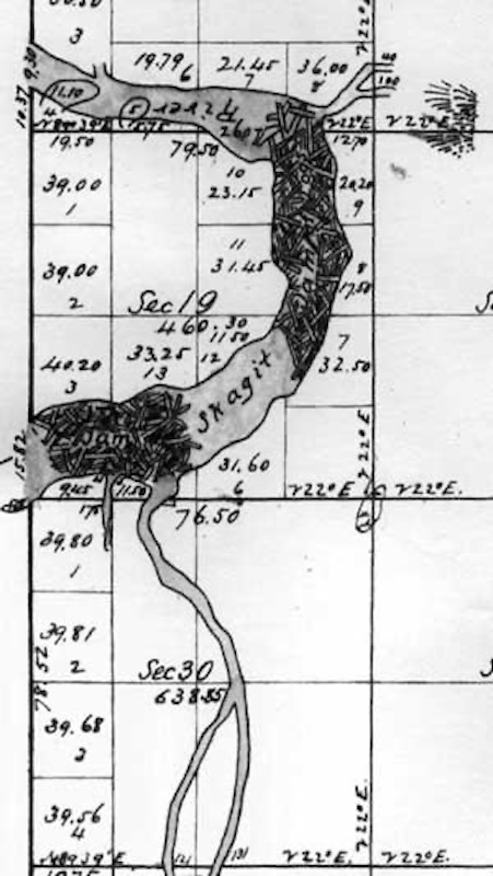
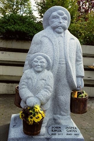
Permanent Euro-American settlement near today’s Mount Vernon began around 1870. Jasper Gates and Joseph F. Dwelley are generally identified as the earliest recorded settlers on the townsite — and we’ll have more to say about Gates and Dwelly in future Tales of the Magic Skagit episodes. Gates established a homestead on the east bank of the Skagit at a time when the surrounding countryside was heavily forested and transportation was almost entirely dependent upon water. It’s location had a somewhat dubious advantage: enormous ancient logjams in the Skagit River impeded navigation farther upstream, giving the area strategic importance as a stopping and transfer point.
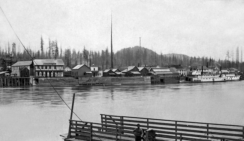
The growing riverside community took recognizable form in 1877 with the arrival of Harrison Clothier, a teacher and farmer from Minnesota. Clothier purchased approximately ten acres of Gates’s property along the riverfront and, together with E. G. English (who had been a former pupil of Clothier), opened a store and laid out the beginnings of a town. A post office was established that November, with Clothier serving as postmaster. The settlement was named Mount Vernon in honor of George Washington’s Virginia estate. The subsequent removal of major river logjams during the 1870s opened the Skagit to increased navigation, making Mount Vernon’s location even more strategic.
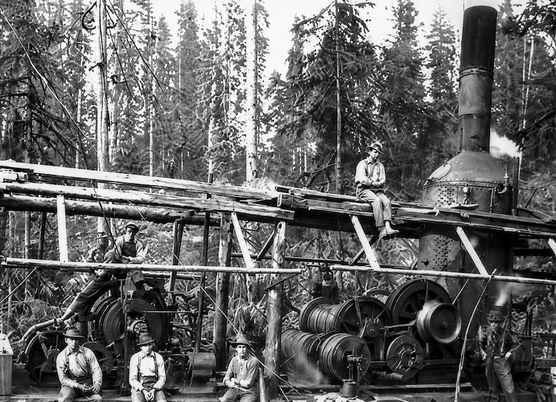
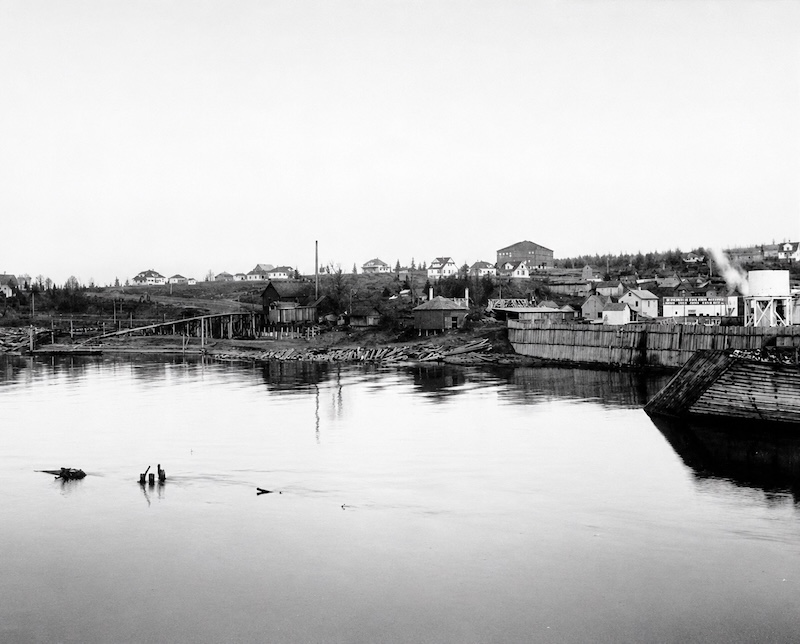
Logging provided much of the settlement’s earliest economic activity. Timber had to be cleared before streets, farms, and buildings could be created, and logging camps proliferated throughout the valley — including Mount Vernon’s iconic topographical feature, Little Mountain. A brief gold rush at Ruby Creek in 1880 stimulated additional activity, although hopes for a major mining boom soon faded. By 1881, Mount Vernon still had only about seventy-five permanent residents, but its central position between Puget Sound and the timber, mining, and farming regions of the upper Skagit gave it advantages that neighboring settlements lacked. Businesses, hotels, churches, fraternal organizations, and newspapers gradually followed.
One of the most consequential developments in Mount Vernon’s history, however, came after Skagit County was created from part of Whatcom County in 1883. Mount Vernon competed with communities including La Conner and Anacortes for designation as the permanent county seat, and it prevailed in an 1884 election. The decision brought government offices, attorneys, businesses, visitors, and political influence to the town and ensured that it would become one of the valley’s principal communities. In June 1890, local voters approved incorporation and elected Mount Vernon’s first municipal government.
The river remained Mount Vernon’s economic highway, and by the late 1880s more than a dozen sternwheelers operated on the Skagit, transporting people, mail, agricultural products, timber, and supplies between river communities and Puget Sound. But a technological change was approaching that would permanently alter the city. The Great Northern Railway completed its line through Mount Vernon in 1891, connecting the community more directly with Seattle, Bellingham, Vancouver, British Columbia, and national markets. The railroad encouraged new businesses and population growth and helped transform Mount Vernon from a river town into a broader regional transportation hub. Of course, as all of us who live here today know, the railroad also cut the town in half. Progress has its price.
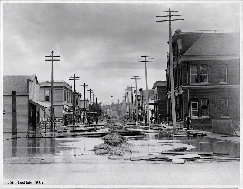
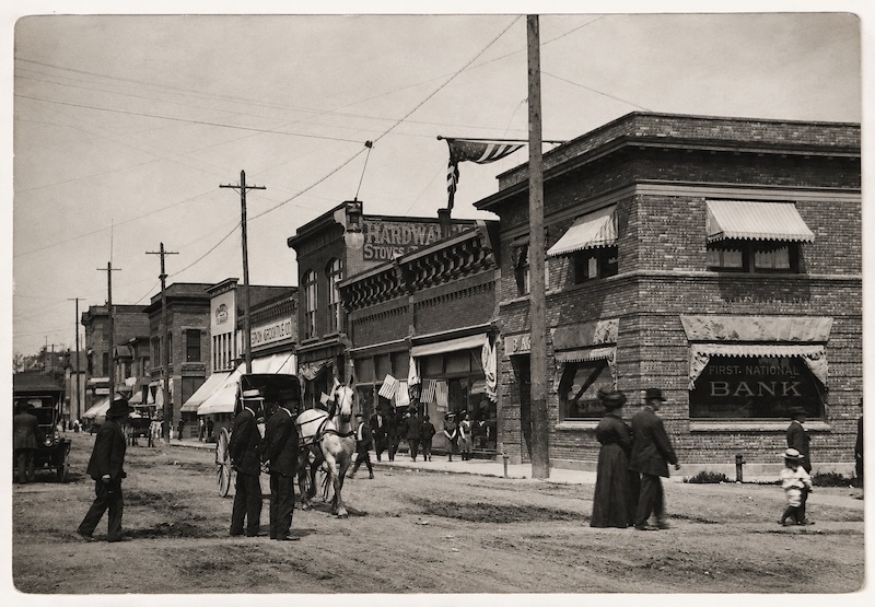
Prosperity did not come without disasters, and in municipalities made of wood (the most plentiful building material) and next to rivers, the main sources of catastrophe were predictable, and inevitable. In July 1891, a major fire destroyed fifteen business buildings and two houses in the older commercial district. Floods followed in 1892 and 1894, encouraging construction of increasingly substantial dikes along the Skagit. Another disastrous fire in 1900 destroyed many remaining pioneer-era buildings, which sadly included the English and Clothier store, and another fire struck downtown businesses in 1903. Repeated rebuilding gradually replaced wooden frontier structures with more substantial commercial buildings, helping give downtown Mount Vernon the architectural character still visible in portions of the city today.
Meanwhile, agriculture was replacing extraction industries as the economic foundation of the surrounding valley. Farmers discovered that the rich alluvial soil deposited by the Skagit could produce exceptional yields. Potatoes, oats, hay, dairy products, vegetable seed, berries, and flower bulbs became important crops. By 1908, the Skagit Delta reportedly produced more oats and hay per acre than any other region in the country. Talk about bragging rights! In later generations, the valley became nationally important for vegetable seed production, and especially famous for tulips and daffodils. How many communities in America devote a month-long celebration to floral blooms? Mount Vernon consequently developed not simply as a farming town, but also as the commercial, banking, processing, supply, and governmental center of a remarkably productive agricultural region.
Transportation changed again during the twentieth century. An electric interurban railway connected Mount Vernon with communities to the north beginning in 1912, but even as this occurred automobiles were increasingly displacing passenger rail. Completion of the Pacific Highway in the early twentieth century strengthened road connections between Seattle and Bellingham, passing through the center of Mount Vernon as well, and Interstate 5 eventually became the dominant north-south transportation corridor. As a result, highway development drew commercial activity away from the old riverfront, particularly toward newer areas north and east of downtown, mirroring a nationwide pattern in which automobile-oriented shopping districts competed with traditional downtowns, generally to the detriment of the latter.
Through every generation of Mount Vernon life, flooding remained a major concern. Historical newspaper records document repeated Skagit floods, prompting decades of debate over dikes, dams, channels, and other flood-control measures. During the enormous 1951 flood, the river rose almost to downtown street level, demonstrating how vulnerable the city remained even mid-way into the 20th century. Mount Vernon residents repeatedly organized emergency sandbagging operations when the Skagit threatened to escape its banks. Flood control therefore became not merely an engineering challenge, but also part of the community’s civic culture. To this day there are plenty of lifelong Mount Vernon residents who can tell you stories of helping build sandbag flood barriers — along with tales of picking berries in the summer to earn money for back-to-school clothes, or more frivolous pursuits such as movie tickets (back when there were three movie theaters in Mount Vernon) and the occasional ice cream soda.
In recent decades, Mount Vernon has increasingly turned its attention back toward its historic riverfront. Rather than treating the river solely as a danger, planners have sought to reconnect downtown with the natural feature most responsible for the city’s existence. A major flood-protection and waterfront redevelopment project ultimately produced a permanent downtown flood wall, which was completed in 2018 — about five years after my wife and I settled here. Besides increasing flood protection, the project created public access and helped encourage reinvestment in the historic downtown; city officials reported that it removed 223 buildings from the regulatory floodplain, not to mention creating a cool outdoor venue for summer concerts and a great place to stroll year round.
Agriculture has likewise remained central to Mount Vernon’s identity — as evidenced by the Skagit County Historical Museum’s current exhibit, “Where Our Food Comes From,” that features a photo documentary of the lives of Skagit Valley farmers and farm workers. The Skagit Valley Tulip Festival, which began as a small celebration in 1984, developed into a month-long regional event centered on the flower fields surrounding Mount Vernon, attracting visitors from around the world. Yet behind the colorful tourism industry lies a deeper agricultural tradition extending back well over a century. The farms surrounding the city continue to distinguish Mount Vernon from many other communities along the I-5 corridor.
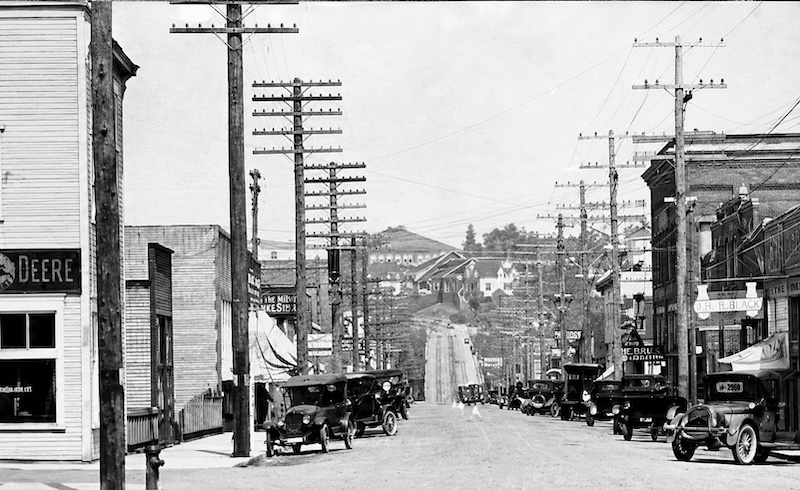
Mount Vernon has changed enormously since Jasper Gates and Joseph Dwelley settled beside the Skagit River more than a century and a half ago, but the fundamental forces that created the city—river, transportation, agriculture, and community—continue to define it. Timber clearing created the first town, while agriculture has given it lasting economic stability. Railroads and highways connected it to the wider Pacific Northwest, even as those transportation changes have repeatedly reshaped its commercial center. Today, traces of each period remain: historic buildings downtown, the courthouse and civic institutions, the farms spreading across the valley floor, the railroad corridor, Interstate 5, and above all the Skagit River itself. Geography is destiny, as Dr. David W. Lantis taught me so many years and road trips ago. I don’t know if his travels as a geographer ever led him to the Skagit Valley, but I have no doubt that he would have understood its history at a very profound level.
In the weeks and months to come between now and the end of the year, Tales of the Magic Skagit will share histories about many of the buildings of downtown Mount Vernon, and we look forward to hearing from our Meyer Sign Facebook followers about their own recollections connected with these sites.
Keep it magic, y’all!
To listen to a historical overview of Mount Vernon written by Skagit Valley historian Dick Fallis, check out this Tales of the Magic Skagit podcast episode below: